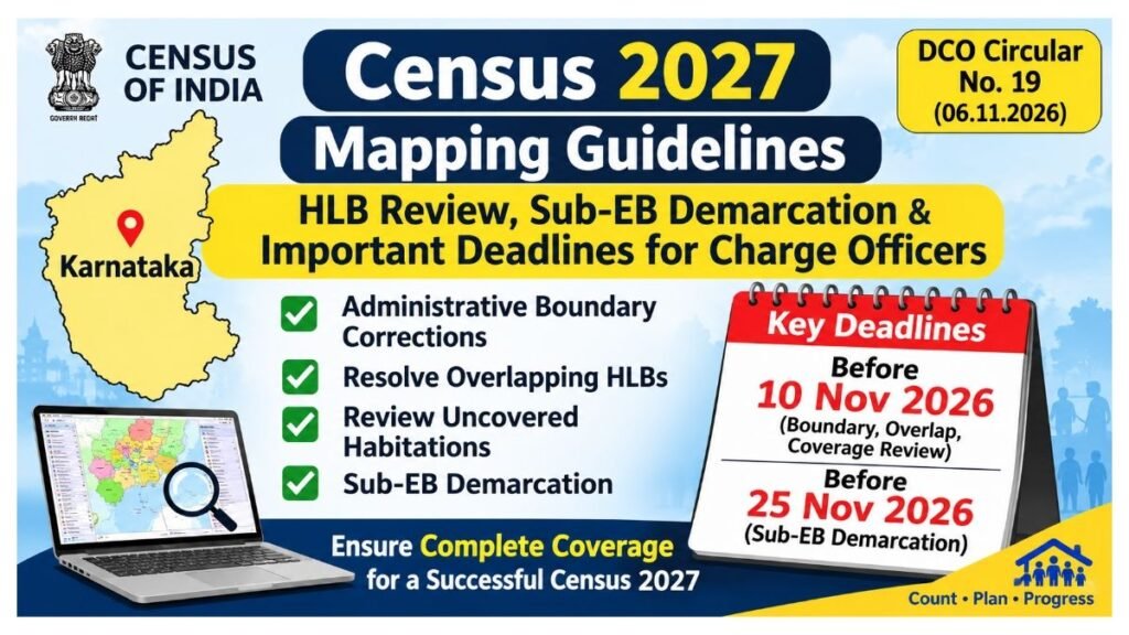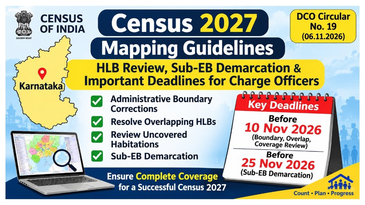
Census 2027 Mapping Guidelines: HLB Review, Sub-EB Demarcation & Important Deadlines for Charge Officers
Census 2027 DCO Circular No. 19 dated 06.11.2026: Check complete mapping guidelines for Charge Officers, HLB Review, boundary corrections, Sub-EB demarcation, EB Maps and important deadlines in Karnataka.
The Office of the Directorate of Census Operations has issued important guidelines to Charge Officers regarding mapping activities for the Population Enumeration (PE) Phase-II of Census 2027. The instructions were communicated through DCO Circular No. 19, dated November 6, 2026, bearing reference number 14/Map/2021 (Miscellaneous)-Part (1).
According to the circular, the first phase of Census 2027, known as the Houselisting Operation (HLO), has been successfully completed in Karnataka. Digital mapping activities were also carried out using the Houselisting Block Creator (HLBC) Web Mapping Application under the Census Management and Monitoring System (CMMS).
Following the completion of HLO, several important mapping activities must be completed before the commencement of Population Enumeration. These activities include administrative boundary corrections, removal of overlapping Houselisting Blocks (HLBs), identification of uncovered habitation areas, formation of Sub-Enumeration Blocks (Sub-EBs), and preparation of Supervisory Circle Maps.
All concerned Charge Officers have been instructed to complete these activities within the prescribed deadlines.
1. Overview of Census 2027 DCO Circular No. 19
Particulars Details Department Directorate of Census Operations, Karnataka Circular Number DCO Circular No. 19 Reference Number 14/Map/2021 (Miscellaneous)-Part (1) Date of Circular 06 November 2026 Subject Guidelines for Mapping Activities – Population Enumeration Phase Census Census 2027 Application HLBC Web Mapping Application Portal Census Management and Monitoring System (CMMS) Last Date for Boundary Corrections 10 November 2026 Last Date for Sub-EB Demarcation 25 November 2026
2. Houselisting Operation (HLO) Successfully Completed
The first phase of Census 2027, the Houselisting Operation (HLO), has been successfully completed in Karnataka with the support of the State Government and Census officials at various administrative levels.
During this phase, digital mapping activities were conducted through the Houselisting Block Creator (HLBC) Web Mapping Application.
The application helped in digitally identifying and demarcating Houselisting Blocks (HLBs) across all districts and charges in Karnataka.
This digital mapping framework will be used for the next phase of Census 2027, namely Population Enumeration (PE).
3. Important Mapping Activities to Be Completed Before Population Enumeration
The circular identifies several preparatory activities that must be completed by the concerned Charge Officers before the Population Enumeration phase.
A. Administrative Boundary Corrections
During the Houselisting Operation, certain discrepancies may have been noticed in the boundaries of administrative units such as:
- Villages
- Towns
- Wards
Charge Officers must identify these discrepancies and record the necessary corrections on the Working Maps supplied during the HLO phase.
The corrected Working Maps must be submitted to the Directorate of Census Operations, Karnataka (DCO) for verification and necessary updates to the Administrative Unit Boundary Database.
Important deadline: All administrative boundary correction requests must be submitted before November 10, 2026.
Charges without pending administrative boundary issues need not wait for other charges to complete the correction process. They can proceed directly with Sub-EB demarcation.
B. Resolution of Overlapping Houselisting Block (HLB) Boundaries
During the digital mapping process, overlapping boundaries between adjoining Houselisting Blocks were identified.
Such overlaps must be resolved before the formation of Sub-Enumeration Blocks to prevent duplication of geographical areas during Population Enumeration.
According to the circular:
- Approximately 24.25 lakh HLBs have been created nationwide.
- Approximately 1.5 lakh HLBs have been created in Karnataka.
- ORGI has undertaken automated processing to correct most technical overlap errors.
- Remaining unresolved overlaps will be flagged for review by the respective Charge Officers.
The existing ‘Overlap’ tool in the HLBC Web Mapping Application has been enhanced and renamed ‘HLB Review’.
This facility is available through the CMMS portal after signing in.
Charge Officers must review and clear all pending overlap issues within the prescribed timeline.
C. Review of Uncovered Habitation Areas
Another important responsibility of Charge Officers is to identify and cover any uncovered habitation areas within their respective charges.
Some habitation areas may not have been included in any demarcated Houselisting Block during the HLO phase.
Such areas will be listed under the ‘HLB Review’ tab in the HLBC Web Mapping Application.
Charge Officers must:
- Review all uncovered habitation areas listed in the HLB Review tab.
- Verify whether the identified areas belong to any Special Charge.
- Include uncovered habitation areas in the appropriate neighbouring HLBs wherever they do not belong to a Special Charge.
- Ensure complete geographical coverage before starting Sub-EB demarcation.
This exercise is essential to avoid omission or duplication of habitation areas during Population Enumeration.
D. Demarcation of Sub-Enumeration Blocks (Sub-EBs)
After resolving overlapping HLB boundaries and including uncovered habitation areas, Charge Officers must complete the Sub-Enumeration Block demarcation process.
HLBs exceeding the prescribed household or population workload criteria identified during the HLO phase must be divided into smaller Sub-Enumeration Blocks.
The Sub-EB demarcation process must be carried out using the ‘Sub-EB Demarcation’ tab available in the HLBC Web Mapping Application.
The purpose of this exercise is to ensure that each Enumerator receives a manageable workload during Population Enumeration.
Charges where administrative boundary issues, overlapping HLBs and uncovered habitation areas have already been resolved can proceed directly with Sub-EB formation.
4. Important Deadlines for Census 2027 Mapping Activities
The DCO circular specifies the following timelines for completing the mapping-related activities.
Important deadlines Sl. No. Activity Deadline 1 Reporting and updating administrative boundary changes Before 10 November 2026 2 Resolution of overlapping HLB boundaries Before 10 November 2026 3 Review of uncovered habitation areas Before 10 November 2026 4 Completion of Sub-EB demarcation Before 25 November 2026
All Charge Officers have been instructed to strictly follow these deadlines and monitor the progress of the activities.
5. Generation of Enumeration Block (EB) Maps
After completing the Sub-EB demarcation process, Enumeration Block (EB) Maps will be generated through the HLBC Web Mapping Application.
These maps will be used for operational purposes during the Population Enumeration phase.
The EB Maps will be:
- Included in the Appointment Letters issued to Enumerators.
- Made available for download through the PE Mobile App.
- Available through the Map Repository module in the CMMS portal.
If any Enumeration Block is modified subsequently, the corresponding EB Map must be regenerated to reflect the latest boundary and attribute changes.
In such cases, the concerned Charge Officer must regenerate the Appointment Letter and issue it again to the concerned Supervisor.
Important instruction: Map generation will operate continuously on a 24-hour basis. Charge Officers must allow at least 24 hours for map generation and processing before checking whether the maps are available.
6. Supervisory Circle (SC) Maps
After completing the formation and assignment of Supervisory Circles within a Charge, the corresponding Supervisory Circle Maps will be generated through the HLBC Web Mapping Application.
These maps will be:
- Used in Appointment Letters.
- Made available for download through the PE Mobile App.
- Regenerated whenever changes are made to the constituent Enumeration Blocks of a Supervisory Circle.
Charge Officers must complete the formation and finalisation of Supervisory Circles well before the commencement of field activities.
This will provide sufficient time for map generation, verification and distribution.
7. Activities to Be Completed After Population Enumeration
The circular also provides instructions regarding the collection and submission of Census mapping records after completion of Population Enumeration.
A. Preparation and Submission of Charge Maps
Charge Maps showing all constituent administrative units, including villages in rural areas and wards in urban areas, will be generated through an automated process.
These maps will be incorporated into the Charge Register, which can be downloaded through the CMMS portal.
After completion of the Population Enumeration phase, the Charge Officer must:
- Download and print the Charge Register from CMMS.
- Verify the contents of the Charge Register and Charge Map.
- Sign and date the certification section provided in the document.
- Submit the duly certified Charge Register and Charge Map to the Directorate of Census Operations, Karnataka.
Submission deadline: Within 15 days of completion of Population Enumeration, along with other prescribed Census records, forms and documents.
B. Collection of EB Layout Maps and SC Maps
Where the HLBC Web Mapping Application was not used, Enumerators and Supervisors must prepare manual EB Layout Maps and SC Maps during the Population Enumeration phase.
These maps contain important ground-level information, including:
- Buildings and Census House numbers.
- Roads and landmarks.
- Settlement patterns.
- Geographical boundaries.
- Other relevant location particulars.
Charge Officers must collect two copies each of the EB Layout Maps and SC Maps from the respective Enumerators and Supervisors.
One complete set must be submitted to the DCO along with the certified Charge Register and other prescribed Census records.
C. Scanning Specifications for EB Layout Maps and SC Maps
The circular specifies the following technical requirements for scanning manually prepared maps. Parameter Specification Map Size A3 Scan Mode Black and White Resolution 200 DPI File Format PDF Compression Medium Quality (80–85%) Maximum File Size 1 MB Preferred File Size 300 KB – 1 MB Orientation Landscape
Important scanning instructions:
- Scan the entire map sheet without cropping.
- Ensure that all annotations and numbering are clearly visible.
- Buildings, landmarks and boundaries must remain legible.
- All relevant details must be preserved in the scanned PDF.
D. Uploading and Reconciliation of Maps
All scanned EB Layout Maps and SC Maps must be uploaded in PDF format through the CMMS – EB Layout Maps Module.
Each map must be uploaded individually so that it can be automatically linked with its corresponding EB Number or SC Number.
Charge Officers must also verify the following details before accepting the maps:
- Location particulars.
- Completeness of the map.
- Legibility.
- Building numbers and Census House counts.
- Landmarks and other relevant particulars.
- Signatures and dates of the Enumerator and Supervisor.
8. Responsibilities of Charge Officers
The DCO has instructed all Charge Officers to give high priority to the mapping activities and closely monitor their progress.
The major responsibilities include:
- Reporting administrative boundary discrepancies.
- Ensuring timely correction of administrative boundaries.
- Clearing overlapping HLB boundaries.
- Identifying and including uncovered habitation areas.
- Completing Sub-EB demarcation before the prescribed deadline.
- Ensuring generation of EB Maps and Supervisory Circle Maps.
- Collecting and verifying Census mapping records after Population Enumeration.
- Uploading scanned maps through the designated CMMS module.
- Submitting the certified Charge Register and other prescribed records to DCO.
9. Conclusion
The DCO Circular No. 19 dated November 6, 2026, provides important operational instructions for the successful implementation of the Population Enumeration phase of Census 2027.
All concerned Charge Officers in Karnataka must complete administrative boundary corrections, HLB overlap clearance and uncovered habitation area reviews within the prescribed timeline. Sub-Enumeration Block demarcation must be completed before November 25, 2026.
Timely completion of these activities will help ensure accurate geographical coverage, avoid duplication and omission of habitation areas, and facilitate the smooth conduct of Census 2027.
All concerned officials are requested to follow the instructions issued by the Directorate of Census Operations, Karnataka.
Frequently Asked Questions (FAQs)
1. What is DCO Circular No. 19?
It is an official circular containing mapping guidelines for Charge Officers for the Population Enumeration phase of Census 2027.
2. When was the circular issued?
The circular was issued on November 6, 2026.
3. What is the reference number of the circular?
14/Map/2021 (Miscellaneous)-Part (1).
4. What is HLO in Census 2027?
HLO stands for Houselisting Operation, the first phase of Census 2027.
5. What is HLB?
HLB stands for Houselisting Block.
6. What is Sub-EB?
Sub-EB stands for Sub-Enumeration Block, created by dividing larger Houselisting Blocks to ensure a manageable workload for Enumerators.
7. What is the last date for administrative boundary corrections?
Before November 10, 2026.
8. What is the deadline for Sub-EB demarcation?
Before November 25, 2026.
9. What is the HLB Review tool?
It is an enhanced facility in the HLBC Web Mapping Application used to identify and resolve overlapping HLB boundaries and review uncovered habitation areas.
10. Where is the HLB Review facility available?
It is available through the CMMS portal in the HLBC Web Mapping Application.
11. What is the purpose of EB Maps?
EB Maps provide geographical details of Enumeration Blocks and are used during Population Enumeration.
12. Where can EB Maps be downloaded?
They will be available through the PE Mobile App and the CMMS Map Repository module.
13. What is the minimum waiting time for map generation?
Charge Officers must allow at least 24 hours for map generation and processing before checking availability.
14. What is the deadline for submitting the certified Charge Register?
Within 15 days of completion of Population Enumeration.
15. What is the maximum file size for scanned EB Layout Maps?
The maximum permitted file size is 1 MB, with a preferred size range of 300 KB to 1 MB.